Flood Risk Assessment London
Expert flood risk assessments across all 32 London boroughs. Thames breach modelling, surface water drainage, SuDS design and LLFA consultation by Aegaea.
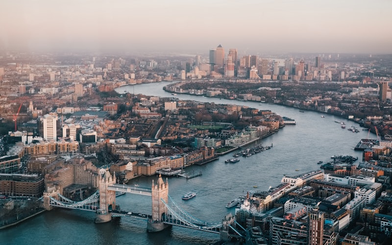
London faces a uniquely complex flood risk landscape. The capital is exposed to tidal flooding from the Thames Estuary, fluvial flooding from the Thames and its many tributaries, extensive surface water risk driven by its vast impermeable urban footprint, groundwater emergence in areas underlain by chalk and gravel, and sewer flooding from a combined Victorian drainage network serving over nine million people. The Thames Barrier and associated tidal defences protect central London from tidal surge, but the residual risk from defence breach or overtopping must be assessed for all development behind these defences.
The Environment Agency’s National Assessment of Flood Risk (NaFRA2) identifies approximately 319,800 London properties at high risk from surface water flooding alone — nearly 30% of all such at-risk properties in England. With 33 local planning authorities each maintaining their own supplementary planning documents, strategic flood risk assessments and drainage policies, navigating London’s flood risk requirements demands specialist knowledge that Aegaea has built over years of working across every borough.
London’s flood risk is further complicated by the interaction between surface water, sewer capacity and tidal locking. When high tides in the Thames prevent outfalls from discharging, surface water backs up through the drainage network. Combined with the capital’s ageing sewer infrastructure — much of it dating from Joseph Bazalgette’s 19th-century construction programme — this creates compound flood risk scenarios that require sophisticated assessment.
Flood Risk Sources in London
Fluvial Flooding
The River Thames and its tributaries present significant fluvial flood risk across London. Major tributaries include the River Lea in east London, the Wandle in south-west London, the Ravensbourne in south-east London, the Brent in north-west London, and the Crane in west London. Many smaller watercourses have been culverted beneath the city, creating hidden flood pathways that can cause unexpected flooding when capacity is exceeded. The Thames floodplain extends across substantial areas of central and west London, with Flood Zones 2 and 3 covering significant development land in boroughs including Richmond, Kingston, Hammersmith and Fulham, and Tower Hamlets.
Tidal Flooding
The Thames Estuary is subject to tidal surge from the North Sea. The Thames Barrier at Woolwich, operational since 1984, provides the primary defence. However, the barrier’s closure frequency has increased markedly — from an average of fewer than two closures per year in the 1980s to over ten per year in recent periods. For sites behind Thames tidal defences, the Environment Agency requires assessment of the residual risk using breach modelling data. This determines finished floor levels, informs safe refuge requirements, and shapes evacuation and flood warning plans.
Surface Water Flooding
Surface water flooding represents London’s most widespread and damaging flood source. The July 2021 storms demonstrated this with devastating clarity, when 54mm of rain fell in just over two hours across parts of east London, overwhelming drainage systems and flooding thousands of properties. Over 160 Critical Drainage Areas have been identified across the capital through the Drain London programme, each representing areas where the combination of topography, impermeable surfaces and drainage capacity creates heightened surface water flood risk.
Groundwater Flooding
Groundwater flooding affects parts of London underlain by permeable geology, particularly the chalk aquifer in south London (Croydon, Bromley, Sutton) and gravel deposits across the Thames floodplain. Rising groundwater levels following the reduction in industrial abstraction have been a concern since the 1990s, with the General Aquifer Research Development and Investigation Team (GARDIT) scheme managing levels in central London. Groundwater can also interact with basement structures, requiring consideration of hydrostatic pressure and waterproofing in development design.
Sewer Flooding
London’s combined sewer system, where foul sewage and surface water share the same pipes, means that intense rainfall can cause sewer surcharging. The Thames Tideway Tunnel, completed in 2025, was designed to intercept flows from 34 of the worst combined sewer overflow points, reducing discharges to the Thames by approximately 95% in a typical year. However, localised sewer flooding remains a risk, particularly where development increases impermeable area without adequate surface water management.
Planning Requirements
London’s planning framework for flood risk operates at three tiers: national policy through the NPPF, regional policy through the London Plan, and local policy through individual borough Local Plans and supplementary planning documents.
The NPPF (Chapter 14) requires the Sequential Test to steer development to areas of lowest flood risk and the Exception Test where development in higher-risk zones is necessary. The accompanying Planning Practice Guidance sets out detailed requirements for site-specific flood risk assessments. The September 2025 updates to the PPG introduced additional emphasis on surface water management and climate change allowances.
The London Plan Policy SI 12 goes further than national requirements. It mandates that development proposals must address all sources of flooding, achieve greenfield runoff rates where feasible, and follow the drainage hierarchy that prioritises rainwater harvesting, then infiltration, then attenuation with controlled discharge. The London Plan also requires developments in areas at risk of flooding to contribute to flood risk reduction rather than simply maintaining existing risk levels.
At borough level, each of London’s 33 local planning authorities maintains its own Strategic Flood Risk Assessment, which identifies flood risk zones and sets local policies. Many boroughs have produced supplementary planning documents covering basement development, SuDS requirements, and site-specific flood risk assessment expectations. Boroughs such as Wandsworth, Hammersmith and Fulham, and the Royal Borough of Kensington and Chelsea have particularly detailed basement and flood risk policies.
Pre-application consultation with the relevant LLFA is advisable for major developments. The Environment Agency is a statutory consultee for developments in Flood Zones 2 and 3 and for proposals involving critical drainage infrastructure.
Key Flood History
July 2021 Surface Water Flooding
On 12 and 25 July 2021, extreme rainfall caused widespread surface water flooding across London. The storms were particularly severe in the boroughs of Hackney, Newham, Waltham Forest, Barking and Dagenham, and Redbridge. Local rainfall gauges recorded 54.1mm in two hours and fifteen minutes during the 25 July event, classified as exceeding a 1-in-100 year storm. Thousands of properties were flooded, with significant damage to homes, businesses and transport infrastructure including multiple Underground stations. Section 19 investigations by affected boroughs highlighted the inadequacy of Victorian-era combined sewers to manage modern rainfall intensities.
January 2003 Tidal Surge
On 1 February 2003, a North Sea storm surge required the Thames Barrier to close. While the barrier held, some areas downstream of the barrier in boroughs including Havering and Bexley experienced flooding. The event reinforced the critical importance of maintaining and eventually replacing the Thames tidal defence system.
August 2020 Flash Flooding
In August 2020, intense rainfall caused flash flooding in south London, affecting areas in Lewisham, Bromley and Croydon. The Ravensbourne catchment was particularly affected, with surface water overwhelming local drainage and causing property flooding along the river corridor.
October 2000 Widespread Flooding
Autumn 2000 brought prolonged rainfall that caused the Thames and its tributaries to reach high levels. Flooding affected properties along the Thames in Richmond, Kingston and downstream areas. The event contributed to the impetus for updated strategic flood risk assessments across London boroughs.
Our Services in London
Flood Risk Assessments
Aegaea has completed flood risk assessments across all 32 London boroughs and the City of London. Our assessments address every source of flooding and are tailored to borough-specific requirements. We routinely work with Thames breach modelling data, Critical Drainage Area policies, and basement-specific planning requirements. Our FRAs range from desktop assessments for minor developments to comprehensive site-specific assessments for major schemes requiring hydraulic modelling and detailed surface water analysis.
Flood Modelling
We undertake detailed hydraulic modelling using industry-standard software including TUFLOW, Flood Modeller and HEC-RAS. For London projects, this frequently involves breach modelling to determine flood depths, velocities and hazard ratings for sites behind Thames defences. We also model surface water flood risk using 2D rainfall-runoff simulations and fluvial flood risk from Thames tributaries where Environment Agency modelling does not provide adequate detail for site-specific assessment.
Drainage Design and SuDS
Meeting the London Plan’s drainage hierarchy requires creative SuDS design, particularly on constrained urban sites. Aegaea designs drainage strategies that maximise source control through green roofs, permeable paving, rainwater harvesting and bioretention features. We prepare detailed drainage calculations demonstrating compliance with greenfield runoff rate targets and produce SuDS management and maintenance plans required by London boroughs.
LLFA and Environment Agency Consultation
Navigating London’s multi-layered regulatory landscape requires effective engagement with the relevant LLFA, the Environment Agency, Thames Water and, where applicable, the Canal and River Trust. Aegaea manages pre-application discussions and statutory consultation responses, resolving technical objections and securing planning approval for complex sites.
Why Choose Aegaea for Your London Project
Aegaea brings unmatched London-specific expertise to flood risk and drainage projects. Having worked across all 33 local planning authorities, we understand the nuances that distinguish one borough’s requirements from another — from Wandsworth’s basement policies to Enfield’s surface water management expectations and Tower Hamlets’ tidal flood risk requirements.
Our team holds detailed knowledge of London’s Strategic Flood Risk Assessments, the Drain London outputs, Thames breach modelling data, and the interaction between the London Plan and borough-level supplementary guidance. This means we can advise on planning strategy from the outset, identifying potential constraints and the assessment work needed to address them before they cause delays.
We have established working relationships with London borough flood risk officers, Environment Agency planning advisors, and Thames Water’s developer services team. When technical objections arise, we know how to address them efficiently because we understand what each consultee needs to see.
For developers, architects and planning consultants operating in the capital, Aegaea provides the specialist flood risk and drainage input that turns a potential planning constraint into a resolved technical matter. We deliver work that satisfies regulatory requirements the first time, avoiding costly delays and re-submissions that erode project programmes and budgets.
Frequently Asked Questions: London
Do I need a flood risk assessment in London?
Yes, if your site is in Flood Zone 2 or 3, within a Critical Drainage Area, or if the development is classed as major (10+ dwellings or 1,000m²+ floorspace). Many London boroughs also require FRAs for basement developments regardless of flood zone.
What is Thames breach modelling?
Thames breach modelling assesses what would happen if the Thames tidal defences were overtopped or failed. The Environment Agency provides breach model data that must be used to set finished floor levels and inform evacuation plans for sites behind Thames defences in central London.
Which LLFA covers my London site?
Each of London's 32 boroughs acts as its own Lead Local Flood Authority. The City of London Corporation serves this role within the Square Mile. Your LLFA is determined by the borough in which your site is located.
What are Critical Drainage Areas in London?
Critical Drainage Areas are zones identified through the Drain London project where surface water flood risk is particularly high. There are over 160 CDAs across London. Development within a CDA typically triggers stricter drainage requirements and mandatory FRA regardless of flood zone.
What surface water drainage rate is required for London developments?
The London Plan requires developments to achieve greenfield runoff rates where feasible. Where this is not achievable, a minimum 50% reduction in runoff rates compared to the existing situation is typically expected. Some boroughs set even stricter requirements.
Can I build a basement in a London flood zone?
Basement development in London flood zones faces significant restrictions. Many boroughs have specific basement policies requiring flood risk assessments, waterproofing to BS 8102, safe means of escape above the breach flood level, and demonstration that the basement will not increase flood risk elsewhere.
How long does a London flood risk assessment take?
A desktop FRA for a minor development in Flood Zone 1 can be completed within 5-7 working days. Detailed FRAs requiring Thames breach analysis, hydraulic modelling or LLFA pre-application consultation typically take 3-6 weeks depending on complexity and data availability.
What is the London Plan Policy SI 12?
Policy SI 12 of the London Plan sets out the flood risk management framework for the capital. It requires development proposals to address all sources of flooding, achieve greenfield runoff rates, and incorporate SuDS in accordance with the drainage hierarchy.